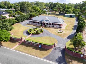
Real Estate Drone Photography
September 27, 2017Aerial Photography Gold Coast
September 27, 2017Aerial Photography Services offers an accurate, cost-effective and reliable way of mapping and modelling projects. Most aerial photography businesses have long-term agreements with international and national clients to offer their services to a wide variety of specifications and resolutions. These firms can mobilize to the site easily due to the latest surveying technology and aircraft.

Most aerial photography providers have great camera operators and pilots who are highly experienced in photography. This ensures that every shot that they offer is the finest composition and of excellent quality. These factors allow them to capture stunning images that represent unique perspectives that can only be achieved by advanced drones.
Aerial photography services enable you to promote or market your home, businesses, property, as aerial images capture the entire property and the surrounding area. This provides you with dynamic images that are ideal for promotional and marketing use.
Benefits of Aerial photography services
Some of the benefits of aerial photography services include:
- Quick Acquisition
Aerial photography offers a quick way to capture the property and the surrounding areas using high-resolution, large image footprint flying camera systems.
- Rapid Mobilization
The use of the latest aircraft or drones makes the mobilization to the site affordable and efficient.
- High Resolution
Aerial photography service providers use high-resolution cameras that allow you to get high-quality images.
- Additional Projects
Aerial photography services offer a stunning source of value-added projects such as 3D modelling, DTMs, and mapping.
Aerial photography service has a variety of applications in different areas that include asset inventory, base mapping, transport and infrastructure and the environment. Aerial photography allows for quick and accurate survey to large areas without disrupting transport networks. Besides, the aerial images offer an accessible record of your site that has the ability to generate great and reliable mapping.
Conclusion
Aerial photography services offer a revolutionary method of inspecting, mapping or marketing property that is cost-effective, safe and quick. The service allows you to get still images or high definition videos that capture all the areas that manual photographers cannot access.
