Navigating Drone Photography Prices Australia
September 22, 2017Forget Traditional Inspection Techniques: Drone Asset Inspection Is The Real Deal
September 23, 2017
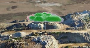
Aerial Mapping UAV offers a revolutionary way to map out locations accurately and safely for clients. It applies to a variety of fields such as industrial, mining and government industries. Use of UAVs in aerial mapping is one of the things that show that drone technology has developed to a level where it is no longer about possibility or hype, but about being friendly and practicality.
The use of UAVs in aerial mapping improves the safety of surveyors and reduces the cost of mapping, as those who are carrying out the process do not need several safety measures. Besides, drones take a few days in mapping a rough terrain as compared to weeks spent by manual mapping. It is, however, wrong to think that drones can inherently change what surveyors, are doing, but UAVs makes surveyors more effective and efficient. Therefore, changing the mapping process depends on how the engineers use the UAVs and other tools to carry out the process.
Drones technology has a broad range of applications in today’s society. Some of the applications include surveying and mapping of infrastructure environments as well as mapping and classification of land cover. UAVs are also suitable for medium and small areas mapping as well as mines, construction sites, gravel pits and remote working. Moreover, drones mapping helps in land surveying for site plans, construction progress documentation and status plans.
Aerial surveying and mapping are useful in orthophotography, cadastral surveys, cartography, topography and regional and urban development. It also helps in inspection and survey of land, dams, embankments and retaining walls.
Conclusion
In conclusion, aerial mapping and photogrammetry industry is fast changing just like other industries. Therefore, there are many questions on the right gear, techniques, cameras, software as well as other parts of this business. It is advisable to get equipment and techniques that provide high-resolution spatial and aerial survey solutions.
Besides, aerial mapping requires working with a reliable and professional team that can offer timely survey data, which enhances productivity in determining a particular geographical location.
