Flare Stack Inspection
September 18, 2017Real Estate Drone Photography Brisbane – Flying Over Your Real Property
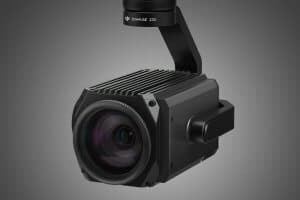
September 18, 2017There are several different cameras on the market. In addition to this, new camera models are coming out every month. However, that does not meanthat acquiring a camera for an aerial inspection service and a surveying task should be difficult. Once you know what to watch out for, choosing a camera should be a breeze.
We will focus on the features you need to consider when selecting a camera for aerial inspection and survey tasks.
What Is Ground Sample Distance?
The quality of shots taken by a drone can be determined by its ground sample distance. Ground sample distance is the real life size of a pixel in the photos taken. If a single pixel on a photomap represents 5 cm on the ground, the photomap will be said to have a ground sample distance of 5 and the photomap can only be accurate to 5 cm, the photomap can be more inaccurate but it cannot exceed an accuracy of 5 cm. If a single pixel represents 1 cm on the ground, the ground sample distance will be 1. The smaller the ground sample distance the better the accuracy is likely to be.
For aerial surveys, the data is expected to be accurate by < 5cm. Several variables determine the ground sample distance, and these are
- Height at with the photo is captured (Altitude)
- The camera’s resolution
- The size of the camera’s sensor
- The aperture
- The focal length of the lens in the camera.
The last four factorsshould be considered when selecting a camera for aerial inspection services.
Resolution
The resolution of the camera is important as it determines the number of pixels on the map and thus goes a long way in determining a map’s ground sample distance. However, the camera sensor also influences the ground sample distance. If two cameras have the same sensor size, the camera with the higher resolution will achieve a better ground sample distance. The resolution for most drone cameras ranges from 12 megapixels to 50 megapixels.
Sensor Size
The larger the sensor size, the better it will be at gathering light to create images. If two cameras have the same resolution, the camera with the bigger sensor will create sharper images. Camera sensor sizes for most drone cameras are Micro 4/3rds, 1”, 2/3”, Advanced Photo System type-C (APS-C) and full frame.
Camera Aperture
Camera Aperture is defined by the amount of light the camera’s sensor is exposed to. Camera aperture is generally marked by the letter f, as in for example f 2.0. While many drone cameras have a fixed aperture, it is better to acquire a camera with a variable aperture. Both high and low fixed aperture can cause images to appear blur depending on conditions such as the distance between object being photographed and the camera sensor. A variable aperture allows you to adjust the aperture and solve this blurry problem.
Focal Length
The focal length of a drone camera is determined by a combination of several technical aspects of the camera. Most unmanned aerial vehicles have lens with focal lengths between 10 mm to 1200mm equivalent focal length. While long focal lengths may work well for aerial inspection tasks, they are notbest for survey tasks that require three-dimensional mapping.
What to Look Out For When Getting a Camera for Inspections
For aerial inspection service purposes, a drone with a 35mm effective focal length, a large camera sensor, and a high-resolution camera is crucial. Autofocus is also an important feature to have in an inspection drone.
In addition, gimbals and vibration isolators provide an advantage, since they cancel out the drone rotors’ vibration that can blur images.
What to Look Out for When Getting a Camera for Mapping and Survey Purposes
Just as for inspections, a large camera sensor and a high-resolution camera are essential. Gimbals are just as crucial here.
Survey cameras should have a mechanical shutter. Since a series of photographs have to be taken quickly to create the maps and models, a mechanical shutter will reduce the rolling shutter effect, which can greatly reduce the accuracy of three-dimensional maps and models.

